Introduction
Drones or unmanned aerial vehicles (UAVs) have come a long way from their early days as simple radio-controlled planes.
The name “drone” actually comes from the 1930s, inspired by a British target aircraft called the “Queen Bee.”
Since then, these unmanned flying machines have evolved into some of the most advanced tools we use today. They now take on tasks that once seemed impossible, like delivering packages to remote locations, monitoring vast stretches of farmland, assisting in search-and-rescue missions, and even conducting precise military operations.
Many of these applications are made possible by integrating drones with artificial intelligence (AI) technologies like computer vision. Computer vision allows drones to see and interpret their surroundings in real-time. This enables them to navigate autonomously, detect objects, and make decisions without human intervention.
The modern era has witnessed an exponential increase in the deployment of drones for various applications, ranging from entertainment to industrial uses. Among these, one of the most transformative applications is in surveillance and security management. With the integration of Artificial Intelligence (AI) and Computer Vision, drones have become highly sophisticated tools capable of enhancing safety, improving response times, and reducing operational costs in security operations. This article delves into how AI and Computer Vision are redefining drone-based surveillance and security management, highlighting their capabilities, applications, benefits, and future potential. For drones, AI development services have set the tone right.
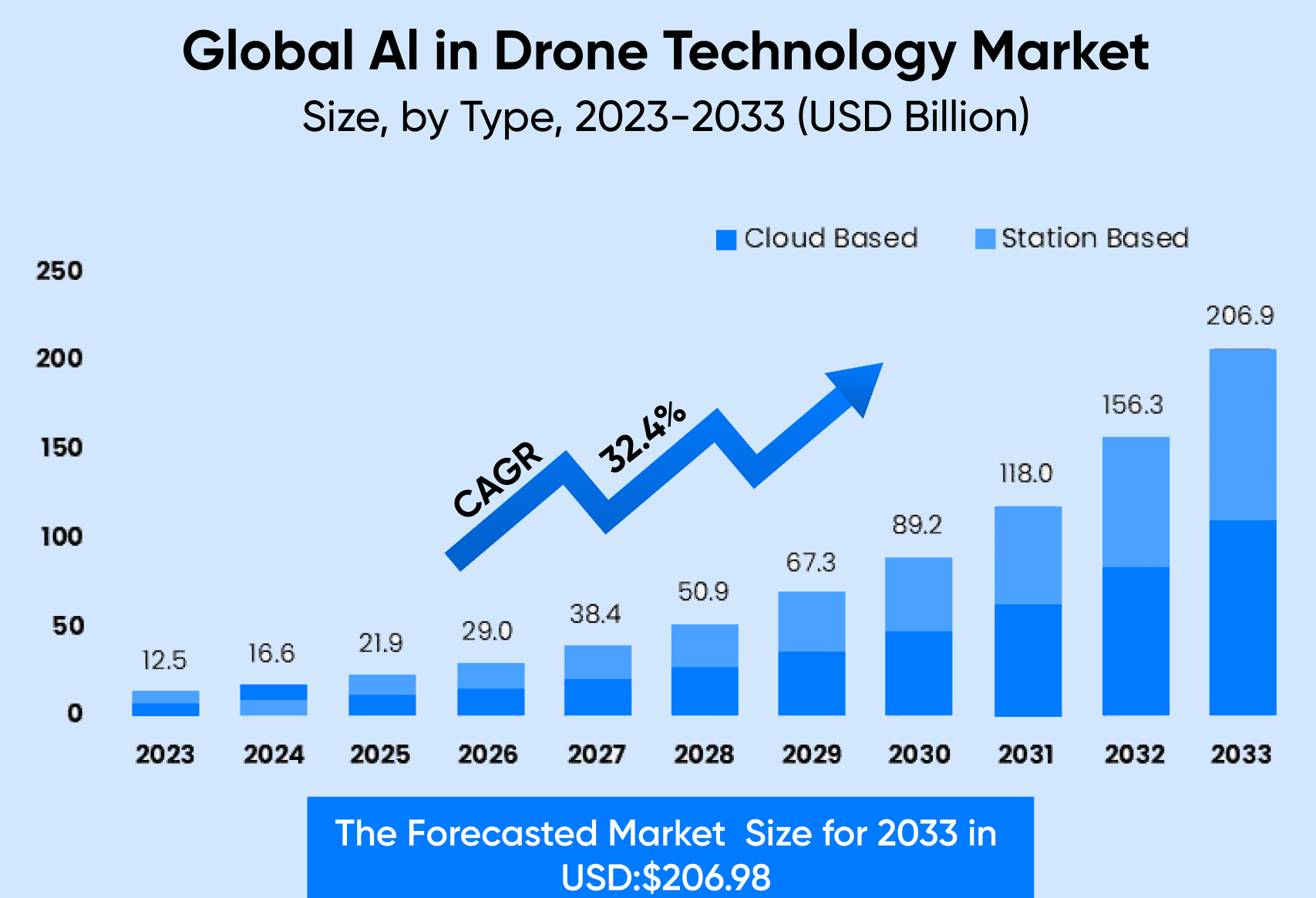
The global AI drone market was valued at approximately USD 12.5 Billion in 2023 and is projected to grow to USD 206.9 Billion by 2033, reflecting a CAGR of 32.4% during this period.
AI gives drones the ability to “learn” and make decisions, making them much more than flying cameras. From helping farmers monitor crops to aiding in search-and-rescue missions, these flying machines are transforming industries in ways we couldn’t have imagined a few years ago.
Enhancing Security and Surveillance with AI-Powered Drones
In the realm of security and surveillance, AI-powered drones have become a game-changer. The incorporation of machine learning algorithms and computer vision tools and drone technology into UAVs has dramatically enhanced their capability to autonomously perform surveillance and security tasks. These drones are increasingly being deployed for real-time monitoring and emergency response, thanks to their ability to autonomously process a vast amount of data and provide actionable insights.
The use of OpenCV in these drones has been pivotal in enabling real-time detection and tracking, a critical aspect of surveillance operations. This technology allows drones to autonomously navigate complex environments and identify potential security threats or emergency situations quickly. The data processed by these drones, often in challenging aerial environments, provides invaluable insights for maintaining security and responding to emergencies efficiently.
Moreover, the advancement in machine learning algorithms has empowered drones to not only gather data but also interpret it autonomously. This capability ensures that drones can be deployed in diverse security scenarios, from urban surveillance to border security, and operate effectively without constant human oversight. The result is a more robust, responsive, and efficient security apparatus, where AI-powered UAVs play a central role in safeguarding people and property.
These developments in drone navigation and security applications demonstrate the profound impact of AI, OpenCV, and machine learning on the capabilities and functionalities of UAVs in various sectors.
Computer Vision: The Eyes of AI in Drones
Computer Vision equips drones with the ability to interpret visual data. By leveraging image and video analysis techniques.
OpenCV, a fundamental tool in computer vision technology, plays a crucial role in the real-time processing capabilities of drones. The integration of OpenCV in drones enables them to process a large amount of visual data swiftly, enhancing their ability to understand and interact with their environment in real-time. This feature is vital in applications where drones need to capture and identify obstacles in real-time and dodge them effectively.
In the context of drone control, OpenCV facilitates the development of more sophisticated and responsive systems. Drones equipped with OpenCV can autonomously navigate complex environments, flying with precision and avoiding obstacles without the need for human guidance. This autonomy is particularly useful in drones used for search and rescue missions, where the ability to quickly process visual information and provide valuable insights can be life-saving.
Furthermore, drones that are used in manufacturing and industrial settings benefit from OpenCV’s real-time processing. These drones can fly over areas like power lines or large industrial facilities, capturing 720p camera images and videos, and processing them on-the-fly to identify structural issues or maintenance needs. The use of OpenCV in drones has also facilitated the creation of 3D models of structures and landscapes, which are created by drones capturing multiple images from different angles.

In summary, OpenCV’s integration into drones enhances their capabilities to autonomously and intelligently navigate and perform tasks, redefining the potential of unmanned aerial vehicles in various sectors. This technology underscores the importance of real-time data processing in the expanding scope of AI drone applications.
How is Computer Vision Integrated into Drone Systems?
So, when we say that a drone is integrated with computer vision, what does that really mean? It means that the drone is equipped with the necessary hardware and software to see, process, and react to visual information in real-time. This integration helps drones to perform complex tasks and make smart decisions.
On the hardware side, it starts with the cameras and sensors. Different types of cameras are used for specific purposes: thermal cameras detect heat, making them perfect for search-and-rescue or monitoring equipment. Optical cameras capture detailed images and videos for tasks like surveying and mapping. LiDAR sensors, on the other hand, create 3D maps of the surroundings using laser pulses, which is critical for precise navigation.
These tools are paired with onboard processors that analyze visual data immediately, enabling drones to respond to changes in their environment as they happen.

The software component is what brings the hardware to life, transforming it into a truly intelligent system. For example, computer vision models like Ultralytics YOLO11 enable drones to detect and track objects such as vehicles or people with precision. In addition, path planning software guides drones along efficient routes, while collision avoidance systems help them travel safely through crowded or obstacle-filled environments. Together, these tools make drones smarter and more capable in real-world scenarios.
How does drone surveillance and security work?
Drone surveillance operates through a combination of advanced technology, involving unmanned aerial vehicles, sensors, and software systems. Surveillance drones are equipped with various types of cameras and sensors, such as high-definition video cameras, infrared cameras, and thermal sensors.
These allow them to capture detailed images and videos even in low-light conditions or at significant distances.
Typically controlled remotely by operators using ground control stations, these systems enable
- navigation
- altitude adjustments
- and camera direction
Some autonomous drones can also operate independently, following pre-programmed flight paths or responding to real-time commands.
The data is transmitted back to the ground control station in real-time, facilitating quick responses to incidents or environmental changes.
Collected data can be stored for later analysis. This is useful for law enforcement and security applications where footage may be reviewed to gather evidence or assess situations post-incident.
Many drone surveillance systems integrate with advanced software that can automate various functions, such as launching, patrolling, and landing, while also analyzing the data to provide insights and alerts based on specific criteria, such as detecting unusual movements or identifying potential threats.
Understanding the Role of AI in Drone Technology
Drones, once simple remote-controlled machines, are now powered by advanced AI systems. These technologies allow them to perform complex tasks autonomously. Let’s break down the key components of AI in drone technology.
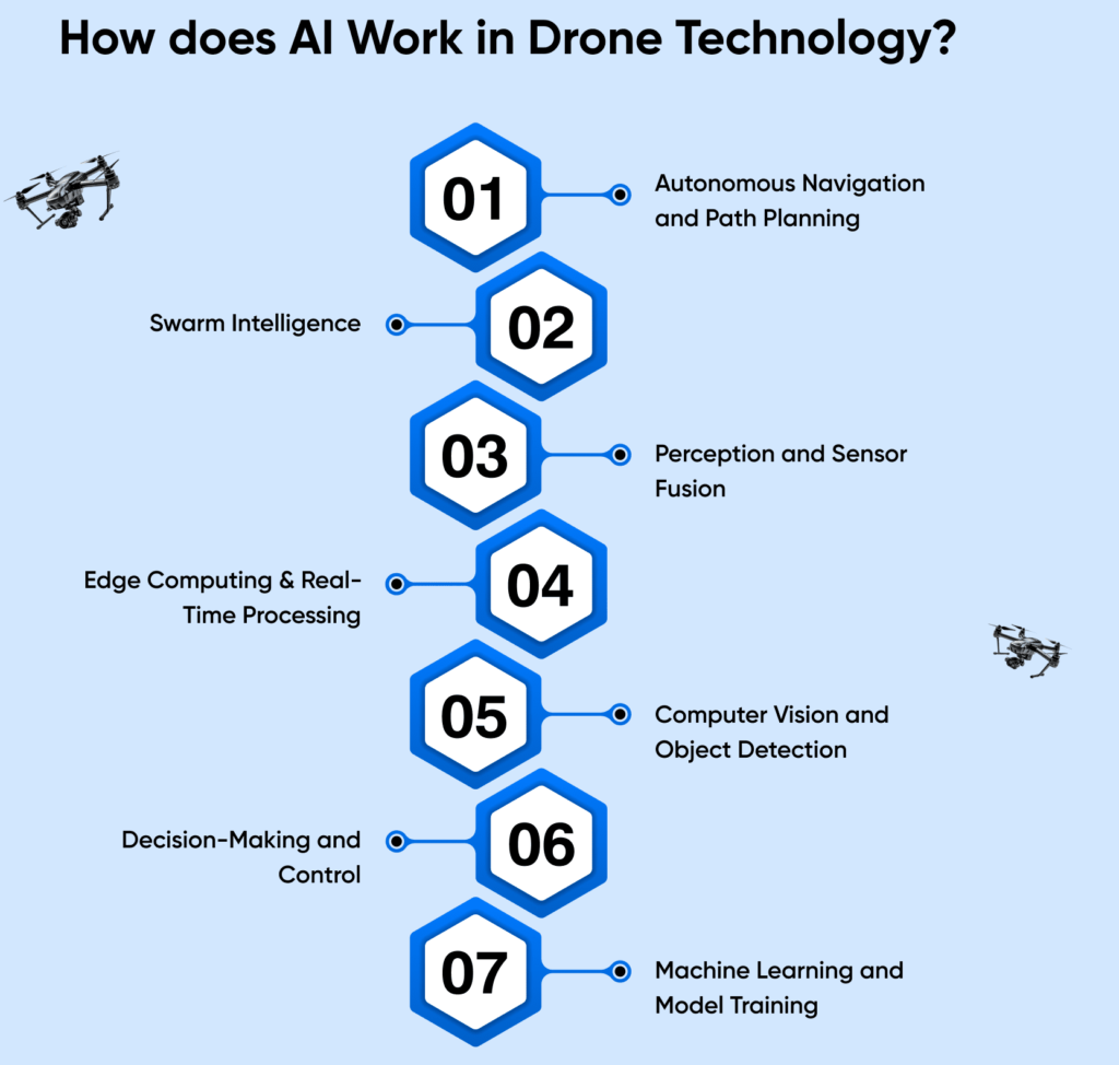
I. Autonomous Navigation and Path Planning
Imagine a drone delivering packages. It needs to navigate through crowded urban environments without human intervention. This is where autonomous navigation comes in. Using algorithms, the drone maps its surroundings and determines the best route to its destination. It avoids obstacles like buildings, power lines, or even other drones.
For example, a drone flying over the desert may use AI to adjust its route if it encounters a sandstorm. Path planning ensures the drone completes its mission efficiently and safely, even in unpredictable conditions.
II. Swarm Intelligence
In situations where multiple drones are deployed, like monitoring large construction sites, swarm intelligence plays a key role. With AI technology drones can communicate and collaborate to finish a big task. Inspired by how ants or bees work together, swarm intelligence helps drones share tasks, avoid collisions, and optimize their coverage area.
III. Perception and Sensor Fusion
To “see” and understand the environment, drones rely on perception. They use cameras, LiDAR, and other sensors to gather data. However, a single sensor may not be enough. This is where sensor fusion comes in—combining data from multiple sensors for a more accurate picture.
For example, an AI drone inspecting oil pipelines might use a thermal camera to detect leaks and a LiDAR sensor to measure the pipeline’s structure.
IV. Edge Computing & Real-Time Processing
Drones need to process data quickly, especially during critical missions. Edge computing enables them to analyze data locally, rather than relying on distant servers. This ensures real-time processing, which is crucial for tasks like avoiding a sudden obstacle or tracking a moving target.
V. Computer Vision and Object Detection
Drones often need to identify objects in their environment. Computer vision enables them to interpret visual data, while object detection helps them recognize specific items like vehicles, people, or landmarks.
In agriculture, drones equipped with AI can detect unhealthy crops by analyzing images. They help farmers in the UAE monitor large fields efficiently, saving time and resources.
VI. Decision-Making and Control
Artificial intelligence in drones makes decisions autonomously. Based on the data collected, the drone can decide its next action like changing direction, adjusting altitude, or returning to base. This is managed through control systems that ensure smooth operation.
For example, during a delivery mission, if the drone detects bad weather ahead, it can decide to reroute or delay the delivery to avoid risks.
VII. Machine Learning and Model Training
At the heart of AI is machine learning. Drones are trained using large datasets to improve their performance over time. For example, a surveillance drone can learn to distinguish between different types of vehicles or detect unusual activities by analyzing past footage.
As technology evolves, drones will continue to play a pivotal role in shaping a smarter, more connected world. Going ahead, let’s see some of the important use cases of AI in drone technology.
Industrial Use Cases of Drone Surveillance Using Computer Vision and AI
Drones equipped with advanced computer vision, like instance segmentation supported by YOLO11, excel in precision tasks across industries. They identify individual objects in scenes, such as power lines or vehicles, making them invaluable for infrastructure inspections and construction. High-resolution cameras and thermal imaging detect cracks or overheating, reducing worker risk and enabling faster maintenance. In construction, drones provide real-time insights, track resources, and create 3D maps to optimize workflows and ensure project timelines. This technology enhances safety, efficiency, and decision-making.
1.Agriculture and Precision Farming
Tree Counting Using Drone Technology
Drones equipped with computer vision and AI are revolutionizing tree counting in large agricultural estates. This technology automates and accelerates the process of analyzing aerial imagery for plantations, which are often expansive, covering thousands of hectares.
A machine learning model trained to detect and count trees can achieve high accuracy rates—often exceeding 95%. This eliminates the need for manual counting and reduces data processing time significantly. For instance, processing data for a 5,000-hectare plantation can be completed in less than an hour, compared to several days with traditional methods.
In addition to counting trees, drones can identify and classify different crop types. The collected data is then integrated into plantation management software, which provides functionalities like:
- Tree Inventory Management: Creating a detailed database of tree assets.
- Block Demarcation: Segregating plantation areas into distinct blocks for better monitoring.
- Health Monitoring: Detecting and flagging trees that are diseased or stressed, enabling timely intervention.
This comprehensive system helps plantation owners optimize operations, monitor crop health, and improve overall productivity in near-real-time.

Identifying Structural Cracks, Corrosion, or Vegetation Overgrowth Using AI-Based Defect Detection Algorithms
Using drones equipped with AI-powered image recognition algorithms, farmers can efficiently identify pest infestations, irrigation issues, and soil anomalies in their fields. High-resolution aerial imagery captured by drones provides a bird’s-eye view of the crops, enabling the detection of subtle patterns or irregularities that might indicate pests or diseases. AI algorithms analyze these images to identify pest-affected areas, often before visible signs appear to the naked eye. Similarly, drones can detect irrigation-related problems, such as overwatering or dry patches, by analyzing moisture levels and plant health indicators. Soil anomalies, including nutrient deficiencies or erosion, can also be identified by processing spectral data and color patterns in the images. This proactive approach allows for targeted interventions, reducing chemical use and improving resource efficiency. The result is healthier crops, higher yields, and more sustainable farming practices.
2.Environmental Monitoring
Drones are transforming environmental monitoring and conservation worldwide, from Africa’s savannas to the Amazon rainforest and Pacific oceans. AI-powered drones provide efficient, non-invasive solutions to critical challenges, such as tracking wildlife populations and detecting illegal poaching with computer vision models like YOLO11.
These drones are also essential in disaster response, assessing damage, identifying affected areas, and locating survivors quickly, enabling faster decision-making and resource allocation. In environmental conservation, AI drones monitor ecosystems, ensuring biodiversity preservation, combating climate change, and supporting sustainable resource use.
In wildlife conservation, drones track animal movements and detect poaching, while mapping wildlife corridors and supporting habitat restoration. In forests, they monitor deforestation, using AI to detect illegal logging and identify reforestation areas.
In marine environments, drones assess coral reefs, identifying bleaching and mapping reef structures for better conservation planning. The integration of AI and drone technology provides real-time data, detects anomalies, and predicts threats, ensuring proactive environmental monitoring and protection of vulnerable ecosystems.
3. Security and Surveillance: People / Car Counting
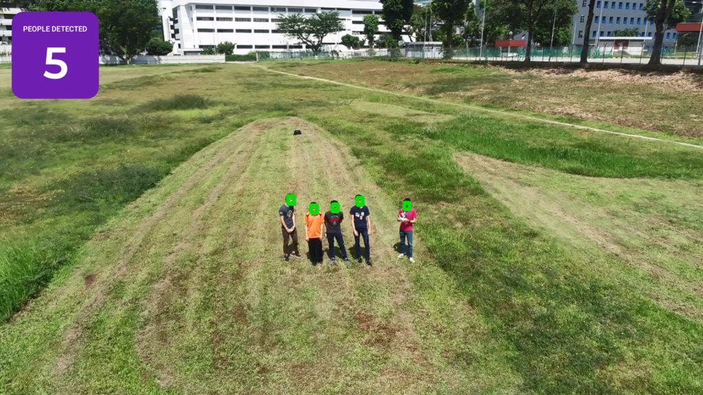
Counting people and objects (such as cars) in aerial footage presents unique challenges compared to land-based applications. The process starts with gathering a sizable amount of annotated drone footage, as deep learning algorithms require high-quality, manually labeled data for training and testing accuracy. Training a model for drone footage demands a larger dataset due to factors like payload range, lighting conditions, time of day, and flight altitude, all of which affect image quality.
For example, objects or people look different when viewed from various angles, such as from the front, obliquely, or top-down. In a face-counting use case, data from drone footage was augmented to replicate eye-level views, with adjustments made to the model to prioritize the top part of the head. The challenge involved working with very small faces, as tiny as 10×10 pixels, in each frame.
Instead of focusing on detailed facial features, the model was optimized to learn the general geometry of face outlines. This resulted in faster computation rates, processing up to 40 frames per second. This optimization proved valuable for security customers, enabling real-time people counting in large crowds using edge processing capabilities on drones.
4.Infrastructure Inspection
In facilities and infrastructure management, traditional inspection methods are often time-consuming and labor-intensive, especially for complex and hard-to-reach structures. Data collection becomes more challenging when the infrastructure is difficult to access by human inspectors.
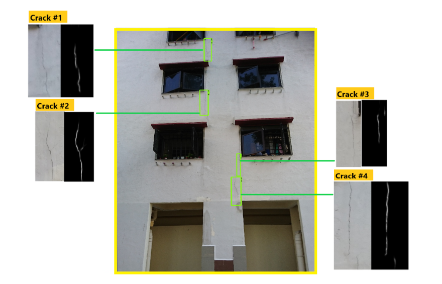
A modern solution involves using drones to capture aerial shots of building facades, followed by an automated defects risk assessment. This system helps identify issues such as cracks and corrosion efficiently, using a multi-step process that balances accuracy and processing speed without compromising privacy.
First, aerial footage undergoes a censorship model that removes personally identifiable information, such as people, car plates, and windows, to protect privacy. Open-source datasets are used for model development to further ensure privacy protection.
The next step involves defect classification, where the system identifies a range of issues like rust, cracks, peeled paint, and cracked glass, based on government standards. However, the model faces challenges with overfitting, as it performs well on fixed datasets, like HDB flats, but struggles with generalizing to new, varied structures.
Conclusion
Industries are increasingly adopting drones integrated with computer vision models. In fact, AI drones are unlocking new levels of autonomy, precision, and efficiency across a wide range of fields – from agriculture and environmental monitoring to military operations and infrastructure inspections.
As computer vision improves, drones are becoming even smarter, capable of making real-time decisions and adapting to dynamic environments. While challenges still exist, the impact of these drones on automation and innovation is undeniable and will only continue to grow. The combination of artificial intelligence and drone technology changes industries as we approach businesses and organizations adopting AI-powered drones gaining advantage and opening doors to growth and innovation. Since the time the first drone was used in 1849 for war, drones or unmanned aircraft systems continue to push the boundaries of what’s possible. Today, they serve as vital tools in various fields, from agriculture to emergency response. While drone surveillance raises concerns, proper regulations and ethical use can harness their potential for positive impact, ensuring safety and innovation coexist.


